- the Birdman of Erindale / Mississauga
&
Bernice Inman-Emery
- the Bird Lady of Mississauga
The
Environmental Significance of the Sawmill Valley
due mostly to efforts by Roy & Bernice over 75 years.
To
Main
Web-page
-
Picture
Gallery
-
News Articles
A key factor is the
Environmental Significance or
Environmental Protection
the Roy Ivor Woods has from development,
what kind of development is possible,
Province of Ontario - Ministry of Nature Resources MNR
Natural Heritage Information Centre
Has it listed as both a Provincial and regional life science Area of Natural and Scientific Interest - ANSI - (Roy Ivor’s Woodlot)
Credit Valley Conservation Authority -
CVCHas it listed as Environmentally Significant Area - ESA - (Ivor’s Bird Sanctuary)
City of
Mississauga Natural Areas Survey -
Fact Sheet
(2006) Currently there are two levels of government - the
Has the most details
as it combines facts from all levels of government.
The big question is, how much of land is covered by this protection?
Some of the fields are empty and many of the ratings are old ones.
In a case like this, the area could be reviewed and found to be no
longer up to its rating, zoning or protection - that takes time and
money. Or in the words of the Mayor Hazel McCallion, the City
down
zones properties.
So just because a property has a high environmental rating and is zoned
for its protection today, does not mean it will always be so. One
old trick used by the Mayor is to let the public do the dirty work.
Turn an high environmental rated forest into a park and in the words of
the Mayor "love it to death" or in the
words of her staff "pounded
it into the ground".
Now do you understand why I don't see the City as the savoir of natural
areas, only one who makes ready for developers.
The Ministry of Nature Resources (MNR), lists the
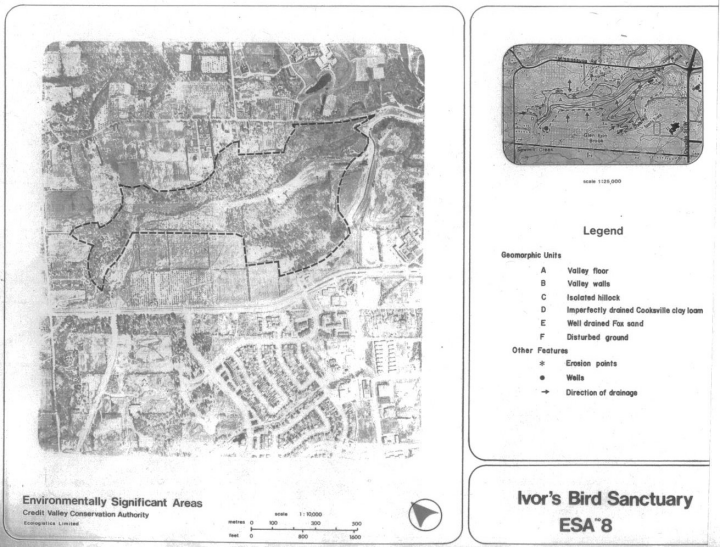
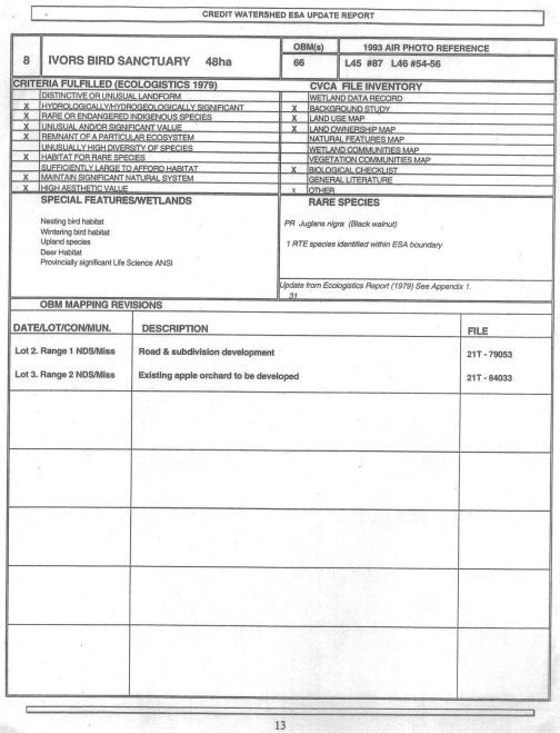
Roy Ivor Woodlot as an Area of Natural and Science Interest (ANSI), details below from the Natural Heritage Information Centre;Natural Areas Report: ROY IVOR'S WOODLOT
Area Id: 106 Area Type: ANSI-LS Alias(es): Size (ha): 34.0
Significance Level:
Provincial Site District: 7E-4 Counties: PEEL Topographic Maps: 30M/12UTM Centroid: 17 607000 4822000 Decimal Latitude/Longitude: 43.5452761998351 -79.6753361817697
Description: Located in Erin Mills, Mississauga, Roy Ivor's upland ravine site is dissected by Sawmill Creek and Glen Erin Brook. The area abuts residential development on its south, east and north sides and is dissected by a proposed road. To the west are abandoned farmlands, proposed for development. Several trails occur throughout the area and tree poaching and vandalism is prevalent. The southern section consists of a series of steep ridges dominated by semi-mature to mature white pine/hemlock/white birch while the northern section contains gently rolling sugar maple/beech/hemlock, hemlock and sugar maple/red oak/hemlock/white pine/ash uplands. [Hanna 1984]
Vegetation:
Landform: The site is located on shale plain and sand plain in the Iroquois Plain physiographic region. The upland and ravine are dissected by Sawmill Creek and Glen Erin Brook. [Brownell 1993]
Representation: Management Agency: Minimum Elevation: Maximum Elevation:
References Id Citation
56599 Varga, S. and K. Mewa. 1998. List of Provincial & Regional Life Science ANSIs in the Greater Toronto Area. Aurora District, Ontario Ministry of Natural Resources. 6 pp.
12289 Brownell, V.R. 1993. Roy Ivor's Woodlot. Pp. 50, in, V.R. Brownell. 1993. Waterfront Natural Areas - Part I: An Overview of Natural Areas along the Lake Ontario Waterfront from Burlington to Trenton. Waterfront Regeneration Trust, Toronto. vii + 193 pp.
4089 Hanna, R. 1984. Life Science Areas of Natural and Scientific Interest in Site District 7-4: A Review And Assessment of Significant Natural Areas in Site District 7-4. OMNR, Parks and Recreational Areas Section, Central Region, Richmond Hill. SR OFER 8404. vii + 69 pp. + folded map, illus.
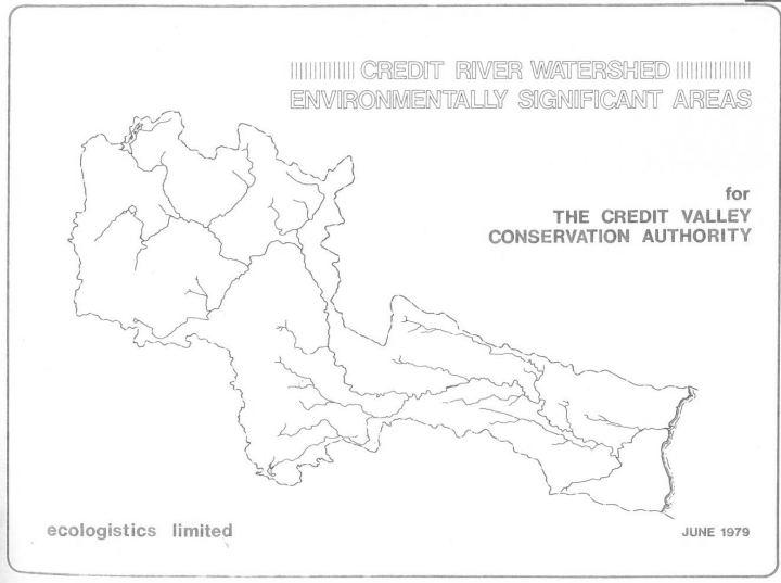
3993 Ecologistics Limited. 1979. Credit River Watershed, Environmentally Significant Areas. Credit Valley Conservation Authority, Mississauga. vi + 207 pp.
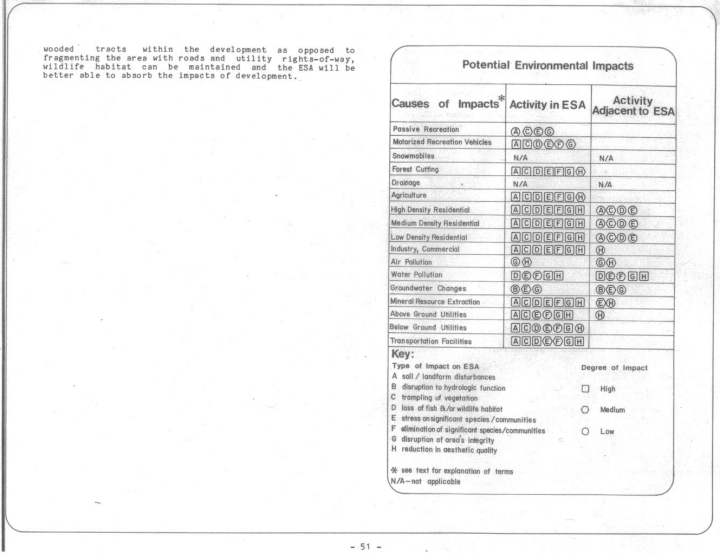
Credit Valley Conservation Authority
{no longer "Authority"} - CVC
There are two main documents
- the 1979 Listings of Environmentally Significant Areas (ESA's) in the Credit River Watershed
- the 1995, ESA update report.
Remember this evidence of how important Roy Ivor's gift to Mississauga's
- future generations really is.
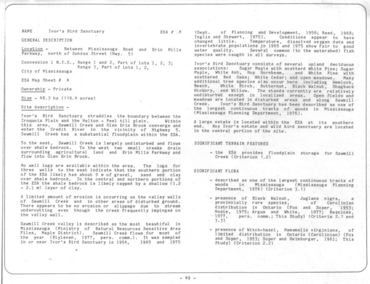
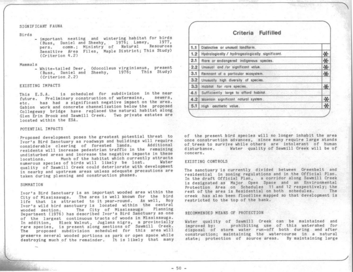
"Ivor's Bird Sanctuary is an important wooded area within the City of Mississauga. ... The City of Mississauga Planning Department (1976) has described Ivor's Bird Sanctuary as one of the largest continuous tracts of woods in Mississauga."
- 1979
"Once described as the and largest tract of continuous woods in Mississauga, Roy Ivor Woodlot, while drastically altered, still remains one of the city's largest forests."
- 1995
1979
1995

| City of Mississauga Natural Areas Survey (2006) |
- Natural Areas Fact Sheet
- the PDF version of this facts sheet - 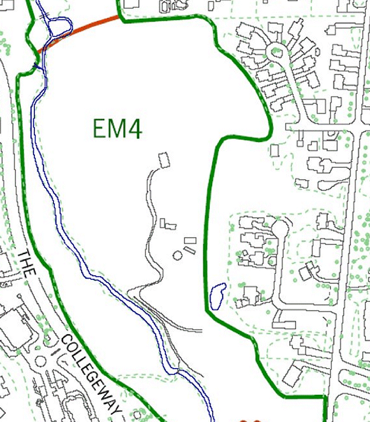 The main house s in the centre - the 2 small structures to the south are old trailer & outbuilding - 3 to the right are the large pens. The road way does go the Mississauga Rd. Below is a larger map, shows Dundas street and Credit River at very bottom, the largest is in the pdf file. 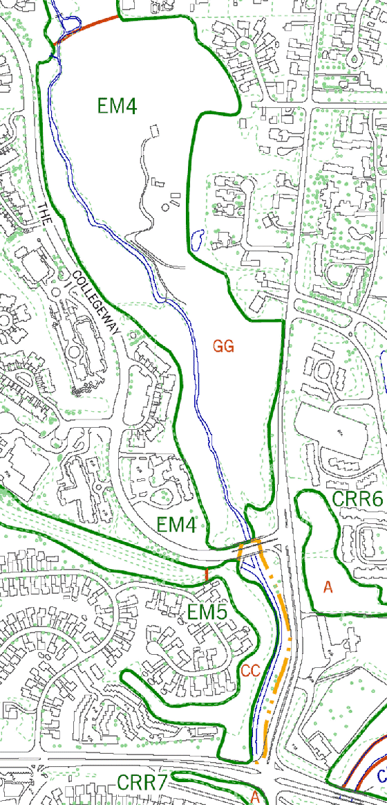 |
| NATURAL AREA NAME - EM4 | PLANNING DISTRICT - Erin Mills | AREA (HA) - 41.93 | UTM GRID REFERENCE - 6059 48221 |
|
1. LOCATION Along Sawmill Creek from the Collegeway in the south continuing northwest to end at Glen Erin Drive. Sawmill Creek links a number of natural areas throughout its length including EM5, EM14, EM10 and CRR7. The natural areas CRR6 and EM2 are located within 500 m to the east, and southwest, respectively. |
|
2. CLASSIFICATION Significant Natural Site |
|
3. DESCRIPTION A. Physical Features The topography of this site varies from steep ravines to undulating floodplain. A substantial portion of the site includes the floodplain of Sawmill Creek. This site is dominated by deposits of the Iroquois Sand Plain in the east and the Halton Till Plain in the west. Northwest of Sawmill Creek the soil type is imperfectly drained Cooksville clay loam that developed within the Halton Till. Northeast of the creek the soil type is well drained Fox sandy loam that developed within the Iroquois Plain. West of Erin Mills Parkway the soil type is well drained Oneida clay loam that developed within the Halton Till. Soil moisture at this site varies from mesic to wet. Where the creek is not engineered with concrete and gabion baskets the red shale bedrock of the Queenston Formation is periodically exposed. There is year round flow in all parts of Sawmill Creek. B. Biota There are 258 floral species and 83 faunal species documented for this site. Seven vegetation communities are present at this site (see accompanying figure); red ash (Fraxinus pennsylvanica)-American elm (Ulmus americana) forest (BB) [fresh-moist lowland deciduous forest type (FOD7-2)], white pine (Pinus strobus)- eastern hemlock (Tsuga canadensis)-sugar maple (Acer saccharum ssp. saccharum) forest (MM) [freshmoist hemlock coniferous forest type (FOC3-1)], sugar maple-American beech (Fagus grandifolia) forest (DD) [dry-fresh sugar maple - beech deciduous forest type (FOD5-2)], sugar maple-eastern hemlock forest (GG) [dry-fresh sugar maple - hemlock mixed forest type (FOM3-2)], wooded non-native valley land (J) [fresh-moist willow lowland forest type (FOD7-3)], old field (C) [dry-moist old field meadow type (CUM1-1)], and sugar maple-American beech-eastern hemlock forest (LL) [fresh-moist sugar maple - hemlock mixed forest type (FOM6-1)]. The red ash-American elm community is located in the extreme south-west corner of the site. To the northeast of this is the white pine-eastern hemlock-sugar maple forest, then the floodplain and finally the sugar maple-American beech forest at the south edge of the Collegeway. Northeast of the Collegeway is the sugar maple-eastern hemlock forest within the floodplain of Sawmill Creek. The wooded non-native valley land and old field communities begin to dominate the floodplain to the north. Between Burnhamthorpe Road and Erin Mills Parkway there is a small sugar maple-beech-hemlock forest. The red ash-American elm community is an immature forest with an open canopy. Red ash and American elm dominate with a dense subcanopy of common buckthorn (Rhamnus cathartica). The disturbed understory is composed of red-osier dogwood (Cornus stolonifera), Virginia creeper (Parthenocissus inserta), yellow avens (Geum allepicum) and garlic mustard (Alliaria petiolata). The white pine-eastern hemlock-sugar maple forest occurs on a series of steep ridges. This is a mature forest with trees between 80 and 117 years old, thus, qualifying as old growth in places. The trees typically have a diameter of 54 cm and can reach 50 m in height. The canopy dominants are white pine, eastern hemlock and sugar maple. Associate species are red maple (A. rubrum), white birch (Betula papyrifera) and black cherry (Prunus serotina). The shrub layer and understory are both very diverse. Common species include witch hazel (Hamamelis virginiana), alternate-leaved dogwood (C. alternifolia), woodland ferns (Dryopteris spp.), baneberry (Actaea spp.), wild ginger (Asarum canadense), wild leek (Allium tricoccum), and trilliums (Trillium ssp.). Good regeneration of the canopy dominants is occurring. The sugar maple-American beech forest occurs adjacent to the
Collegeway. Mature sugar maple and American beech dominate this
closed canopy with red oak (Quercus rubra) as the associate.
The shrub layer is dense with choke cherry (P. pensylvanica).
The understory is depauperate but includes wild leek, Jack-in-the-pulpit
(Arisaema triphyllum) and false Solomon’s-seal (Maianthemum
racemosum). The trees in this forest community are 80 to 120
years old thus contain old growth elements, and are typically 48 cm The sugar maple-eastern hemlock forest occurs on the rolling floodplain of Sawmill Creek. Mature sugar maple and eastern hemlock form a closed canopy with red oak and American beech as the associates. The understory here is composed of meadow rue (Thalictrum spp.), blue cohosh (Caulophyllum thalictroides), tall buttercup (Ranunculus acris), large-leaved aster (Aster macrophyllus), and false Solomon’s-seal. The canopy is 40 m in height and the trees are typically 36 cm in diameter. Red oaks reaching 112 cm in diameter and eastern hemlock reaching 79 cm in diameter are not uncommon. The wooded non-native valley land community also occurs along the floodplain of Sawmill Creek. Scattered mature willow (Salix alba) and red ash form an open canopy above a subcanopy of Manitoba maple (A. negundo). Riverbank grape and the invasive species garlic mustard, multiflora rose (Rosa multiflora), and Tartarian honeysuckle (Lonicera tatarica) are prevalent in the dense understory. The old field community occurs in scattered locations along the edge of the site. Common species include tall goldenrod (Solidago altissima), bird vetch (Vicia cracca), wild carrot (Daucus carota), smooth brome (Bromus inermis ssp. inermis), and orchard grass (Dactylis glomerata). The sugar maple-American beech-eastern hemlock forest is located
within the floodplain of Sawmill Creek. The open canopy is
dominated by immature sugar maple, American beech, and eastern hemlock
with black walnut (Juglans nigra) as the associate. The
canopy trees in this community are also greater than 100 years old. |
|
4. CONDITION This site currently ranges between good (southern portion) to fair (northern portion) condition. Some of the more common disturbances are an extensive paved formal trails, as well as an unpaved, unplanned trail network, a mountain bike course, evidence of bush parties, extensive trampling at the bottom of the coniferous slope, past logging evidence, tree poaching, vandalism, erosion on valley walls, residential encroachment, and extensive soil compaction. Gabion baskets and concrete channelization have replaced the natural habitat along sections of Sawmill Creek. Channel improvements are planned along Sawmill Creek throughout this site. In 1998 work was conducted from the Collegeway to Featherstone Drive. Recent development has resulted in a reduction in the area of the site and subsequent boundary revisions. A field visit in 1999 indicated that most of the sugar maple-American beech community has been removed on the west side and there appeared to be tree mortality in the floodplain. The floodplain community was removed by townhouse development prior to 2006. Invasive plant species prevalent at this site include garlic mustard, common buckthorn, multiflora rose, Tartarian honeysuckle, and dog-strangling vine (Vincetoxicum nigrum). Seven-six introduced plant species are present at this site (representing 29.46% of the total number of species present). The native FQI value continues to increase from 55.05 in 1996 and 56.25 in XX to its present value of 57.15. In contrast, the native mean coefficient continues to decrease from 4.30 in 1996 and 4.26 in xx to its present value of 4.241. Surrounding land use is residential. |
|
5. SIGNIFICANCE * High FQI and native mean coefficient. * This site is designated as an Environmentally Significant Area (Ivor’s Bird Sanctuary), and both a provincial and regional life science Area of Natural and Scientific Interest (Roy Ivor’s Woodlot). * Important nesting and wintering habitat for birds. * Butternut (Juglans cinerea) considered a “species at risk” within the province (COSSARO) and nationally (COSEWIC) is documented from this site. * One species documented for this site, woodland satin grass (Muhlenbergia sylvatica), is considered rare within the province by the NHIC. * Four plant species documented for this site are considered rare within the City (known from 3 or fewer locations). These species are: crested wood fern (Dryopteris cristata), woodland satin grass, one-seed bur-cucumber (Sicyos angulatus)2, and river wild-rye (Elymus riparius). * Thirty-two plant species documented for this site are considered uncommon within the City (known from 4 to 10 locations). These species are: rattlesnake fern (Botrychium virginianum), glandular wood fern (D. intermedia), interrupted fern (Osmunda claytoniana) oak fern (Gymnocarpium dryopteris), American yew (Taxus canadensis), tamarack (Larix laricina), bottle-brush grass (Elymus hystrix), the sedges (Carex intumescens, C. scoparia), starry false Solomon’s-seal (Maianthemum stellatum), slippery elm (Ulmus rubra), long-leaved chickweed (Stellaria longifolia), round-lobed hepatica (Anemone americana), three-leaved toothwort (Cardamine x maxima), foam flower (Tiarella cordifolia), swamp red currant (Ribes triste), Saskatoon-berry (Amelanchier alnifolia), hawthorn (Crataegus succulenta), Canada plum (Prunus nigra), barren strawberry (Waldsteinia fragarioides), mountain maple (Acer spicatum), black ash (Fraxinus nigra), Indian hemp (Apocynum cannabinum), Canada honeysuckle (L. canadensis), downy arrow-wood (Viburnum rafinesquianum), Indian tobacco (Lobelia inflata), great lobelia (Lobelia siphilitica), American groundnut (Apios americana), pearly everlasting (Anaphalis margaritacea), Canada honewort (Cryptotaenia canadensis), pointed-leaved tick-trefoil (Desmodium glutinosum), marginal fern wood (Dryopteris marginalis), and river wild-rye (Elymus riparius). * Five resident bird species are considered species of concern by the Credit Valley Conservation Authority. These species are: common grackle, eastern wood-pewee, pine warbler, red-breasted nuthatch and gray catbird. * Large size (41.93 ha). * Close proximity to natural areas EM2 and CRR6. * Directly connects to natural area EM5. * Contributes to the linkage function of Sawmill Creek and the Credit River. * Floodplain provides floodwater storage for Sawmill Creek. * Diversity of plant species (258 species). * Diversity of vegetation communities (7 communities). * Canopy trees greater then 100 years old. * The white pine-eastern hemlock-sugar maple forest, the sugar maple-eastern hemlock, and the sugar maple-American beech-eastern hemlock forest are uncommon vegetation communities within the City. |
|
6. MANAGEMENT NEEDS * The City parks, Windy Hollow and the Sawmill Valley Trail, are included within this natural area. * This is an excellent site in the context of the City and should be a priority for a Conservation Plan, especially in view of the recent development that has infringed on the site. * Exotics in some areas (i.e., the red ash-American elm forest and the wooded non-native valley land) pose a significant threat and should be managed. Dog-strangling vine in particular should be eliminated through soil removal or herbicides before it becomes more widespread. This species can spread quickly to other areas and no effective control strategies are known for it. * Impacts from the proximity to residential areas warrants control of access. |
|
7. PRINCIPLE REFERENCES Brownell (1993) Bruce A. Brown Associated Limited (1994) City of Mississauga (1978b) Construction Control Inc. (1998) Dougan and Associates (1997b) Ecologistics Limited (1979) Ecoplans Limited (1988b) Hanna (1984) LGL Environmental Research Associates (2002) Milus Bollenberghe Topps (1982) Proctor & Redfern Limited (1992) Starr Landscape Group Limited (1978) Transportation and Works (1998) |
|
1 - Floristic quality is explained in the method section (2.3). 2 - Historical record, this species has not been documented for this site since 1973. |
To
Main Web-page
-
Picture Gallery
-
News Articles
Home page - Main Table of Contents - Back up a Page - Back to Top